


![]()
![]()
![]()
![]()
![]()
![]()
![]()
![]()

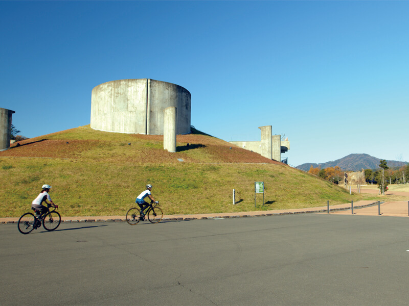
「ゴコイチ」とは、三方五湖をぐるりと一周するサイクリングコースの愛称です。
湖のそばを走り、五胡それぞれの違った景観や特徴を楽しみながら走ることができる、風光明媚なコースです。
距離は約33㎞と比較的短く、高低差もほとんどないため、さまざまなサイクリング愛好者の方に楽しんでいただけます。
単に走り抜けるサイクリングコースが多い中、ゴコイチサイクリングコースは、湖面ギリギリを走る爽快感や土地の魅力をゆっくりと味わいながら走れることで人気が高まっています。
鉄道の駅や高速道路のインターチェンジからもほど近く、県内外を問わずアクセスしやすい場所にあります。
“Gokoichi” is a nickname for a cycling course that goes around the Mikata Five Lakes.
It is a scenic course where you can run by the lake and enjoy the different scenery and characteristics of each of the five lakes.
The distance is relatively short, about 33 km, and there is almost no difference in elevation, so it can be enjoyed by various cycling enthusiasts.
While there are many cycling courses where you can simply run through, the Gokoichi Cycling Course is growing in popularity because you can run while slowly enjoying the exhilaration of running on the surface of the lake and the charm of the land.
It is close to railway stations and expressway interchanges, and is easy to access regardless of whether you are inside or outside the prefecture.
「ゴコイチ」とは、三方五湖をぐるりと一周するサイクリングコースの愛称です。
湖のそばを走り、五胡それぞれの違った景観や特徴を楽しみながら走ることができる、風光明媚なコースです。
距離は約33㎞と比較的短く、高低差もほとんどないため、さまざまなサイクリング愛好者の方に楽しんでいただけます。
単に走り抜けるサイクリングコースが多い中、ゴコイチサイクリングコースは、湖面ギリギリを走る爽快感や土地の魅力をゆっくりと味わいながら走れることで人気が高まっています。
鉄道の駅や高速道路のインターチェンジからもほど近く、県内外を問わずアクセスしやすい場所にあります。
マップ詳細へ※オンラインの地図上でサイクリングルートが閲覧できるウェブサイト「ルートラボ」が2020年3月末でサービス終了したため、「bikemap」に変更したことで、bikemap内の距離や高低差に誤差が生じている場合がありますが、ご理解ご了承の程、よろしくお願いします。
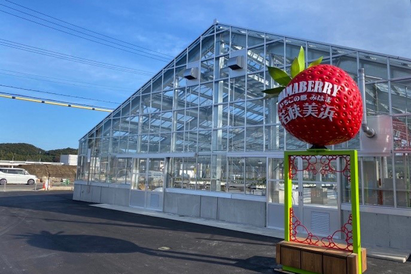
最新の技術を駆使し、嶺南の気候を最大限に活かしたイチゴに最適な環境を作っています。爽やかで品のある香りの『かおり野』、どなたにでも好まれる甘みと酸味のバランスのとれた『紅ほっぺ』、甘味・酸味・風味が四つ星級においしい『よつぼし』など、多品種を揃えています。

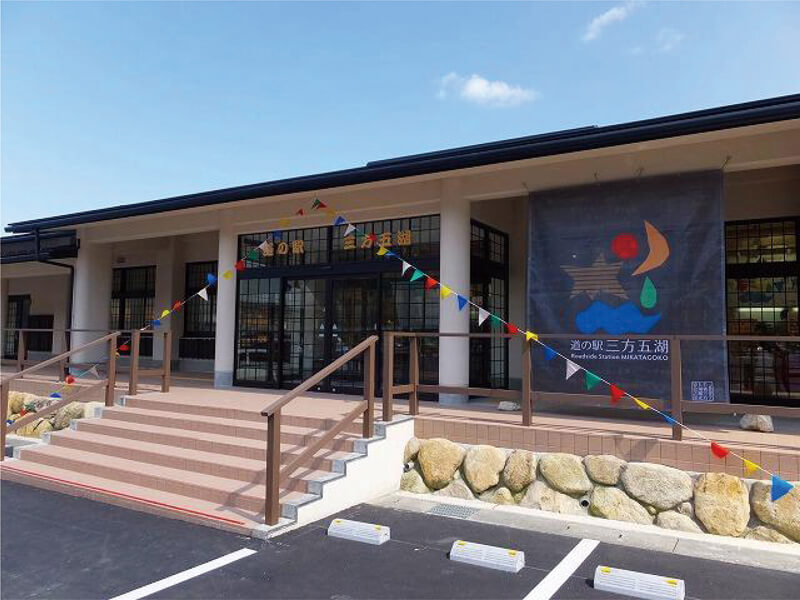
15年ご愛顧いただいておりました 五湖の駅が「九十百千KOTOMOCHI」として令和5年4月15日リニューアルオープンいたしました。九十百千とは「ひふみ祝詞」の一部です。森羅万象の恵みを受けたこの若狭の地で 神秘の湖三方五湖の年縞のように 7万年の積み重なった歴史を次世代へ繋いでいきたい。 和の心のおもてなしを目指しています。 九十百千食堂では ふくこむぎを使った自家製おうどん、もみ殻で炊いた羽釜ご飯、おむすび、おどんぶり、お蕎麦がございます。 また別館売店では美浜のへしこ・地酒早瀬浦・梅酒各種 梅干し等お求めになれます。 敦賀神楽の「中道源蔵茶舗」も出店。テイクアウトカフェをお楽しみいただけます。美しい四季の田園風景を眺めながらゆっくりとした時間の流れを感じていただければ幸いです。
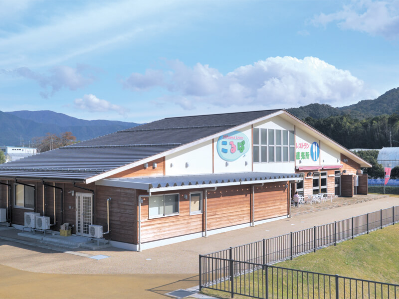
旬の野菜や果物、海の幸を使った料理などを楽しんでいただけます。また、食と健康にまつわる楽しいセミナーも開催するほか、直売所では地元の野菜や特産品などをご用意しております。
三方五湖を望む丘の上にある施設。福井県でここにしかない「巨木トマト」や季節の花々を見学することができます。イベントも豊富に開催しており「科学」「調理」「工芸」各分野のいろいろな体験をお楽しみいただけます。
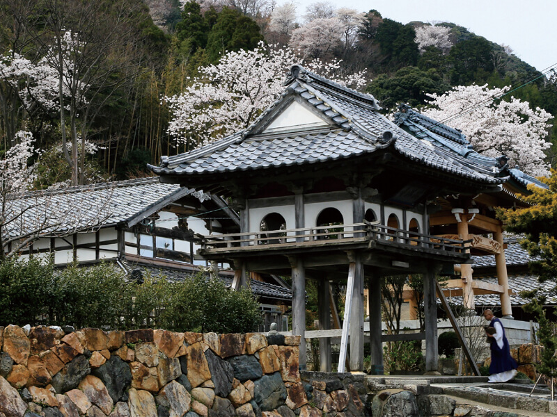
さだまさしさん原作映画「サクラサク」の舞台となったお寺。永享2年に天章光祐大和尚によって創建された古刹で、若狭三十三観音霊場の四番札所にあたります。本尊は釈迦三尊で、本堂正面に祀られています。瑞林寺横にある「一本桜の丘(福井ふるさと百景認定)」からは、形のキレイな一本桜と小高い丘からの景色との調和が楽しめます。
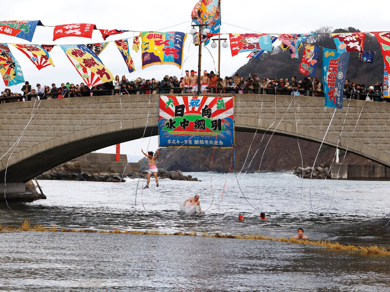
若狭湾と日向湖を繋ぐ運河上にある橋で、ゴコイチをめぐるサイクリストにとって一つのランドマークになります。この橋の上からはエメラルドグリーンに透き通る美しい運河の様子や若狭湾に漁に出る漁船の姿を見ることができます。毎年1月の第三日曜日に行われる「日向の水中網引き」は国選択無形民俗文化財に指定されており、勇壮な神事は必見。運河上に長さ40mもの網を渡し、橋の上から飛び込んだ若者たちが全身を真っ赤にしながら網切りの競い合いを行います。
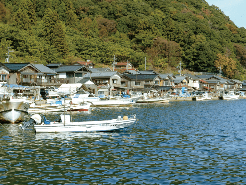
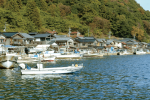
若狭湾につながる日向湖の周囲にはびっしりと漁業関係者の建物が建ち並び、日本の原風景のひとつとも言える懐かしい景観を見せてくれます。釣り客の訪問も多く、周囲には民宿や釣り堀などもあり、訪れる人を楽しませてくれます。
約1.5㎞にわたって町並みを景観できます。

海漁と安産の守護神・鵜葺草葺不合尊が祀られている神社。創建は現在の美浜町日向に701年と古く、806年に現在の位置に遷座した。毎年4月8日に豊作や豊漁、国の平安を祈って行われる古舞楽「王の舞」をはじめとする「宇波西神社の神事芸能」は国選択無形民俗文化財になっている。
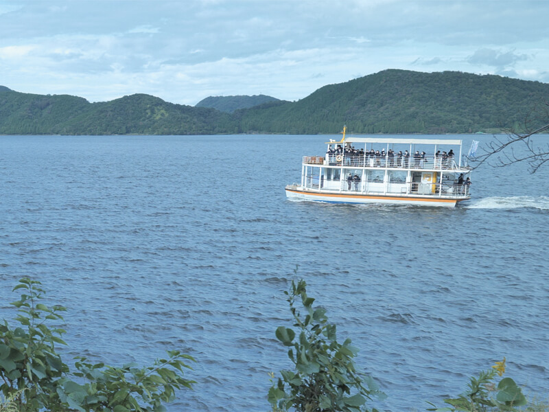
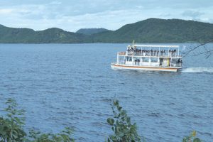
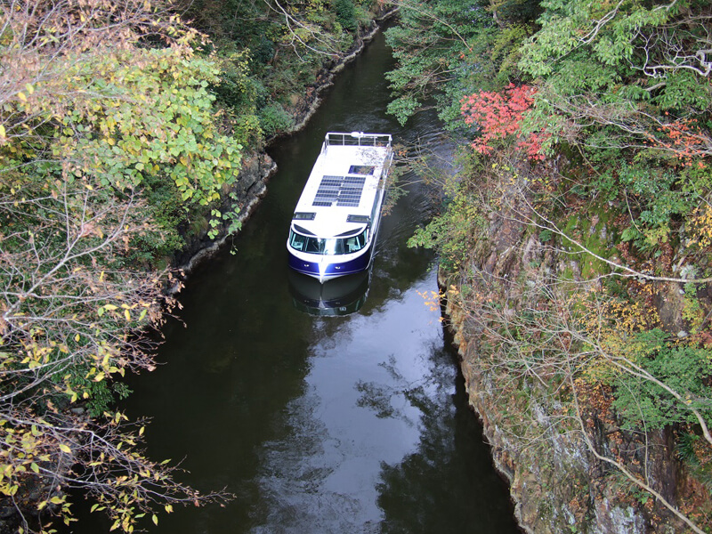
水月湖と菅湖をめぐる、約40分間のクルージングを楽しむ遊覧船。船は2階建てとなっており、1階部分は冷暖房完備で心地よく、2階部分はオープンデッキとなっていて水面をわたる風を感じながら、バードウオッチングなどを楽しめます。
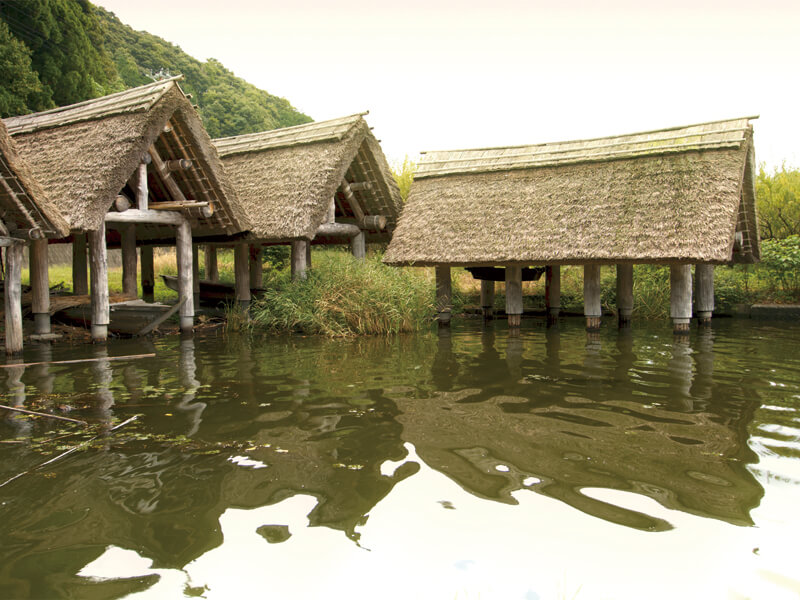
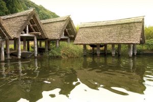
三方湖の湖畔にある舟小屋。かつてこの舟小屋から舟を出して湖対岸にわたり、梅の収穫を行っていました。合掌造りの舟小屋と湖の風景は一枚の絵のようです。梅の花の咲く頃や、雪景色の舟小屋は静かな美しさをたたえ心に染みる風景です。
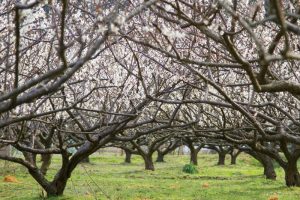
若狭は日本海側最大の梅産地で、その多くは若狭町の三方五湖周辺で栽培されています。主品種の「紅映(べにさし)」は、実に赤みが差すことからその名前がついており、種が小さく果肉が厚いことが特徴。ほぼ県内のみで栽培される希少品種で皇室への献上、大相撲優勝力士へ贈呈されているとても品質が高い梅です。
およそ成出(なるで)から海山(うみやま)周辺に広がっています。
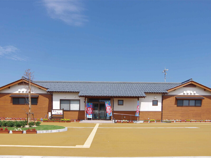
「三方湖」に面し、テラスから臨む四季おりおりの眺めや飛来する野鳥が心を落ち着かせてくれる、自然いっぱいの道の駅です。日本海側最大の梅の産地であることから直売所には梅加工品が数多く取揃い、旬の時期には店内にいい香りが漂います。レンタサイクルも完備し、サイクリングの発着点として利用されています。観光案内所では観光施設や宿泊案内を、野鳥観察棟ではラムサール条約登録の湿地や野鳥のきめ細かい情報を提供しています。
若狭町の鳥浜貝塚から出土した遺物を中心に、縄文文化をテーマにした博物館。土偶のお腹をイメージした建物の中には、縄文遺跡から出土した丸木舟や縄文土器、石器、木製品、種子、骨などが展示されています。竪穴式住居が再現されている縄文広場などの憩いの場もあります。
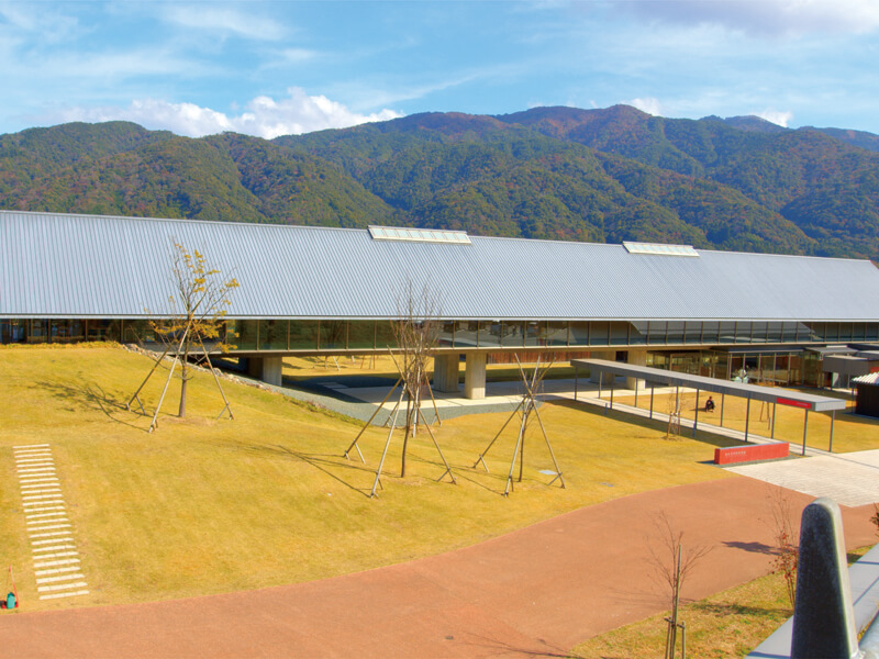
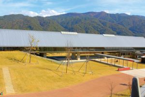
水月湖の湖底にある縞模様の地層「年縞(ねんこう)」をテーマにした博物館。館内では世界最長の7万年分・45mの実物を展示するほか、過去7万年間の人類や環境の歴史も紹介しています。併設のカフェでは、湖を眺めながらゆったりとした時間を過ごせます。2018年9月の開館以降、第2回日本博物館協会賞や第61回BCS賞、科学ジャーナリスト賞2023特別賞など数々の賞を受賞しています。
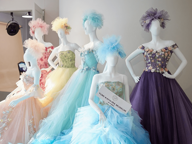
世界的なブライダルファッションデザイナー「YUMIKATSURA MUSEUM WAKASA」をはじめ、銀婚金婚式、誕生日など記念日体験、ドレス工場の見学、ワークショップ、またカフェや画期的なPHOTOオフィスなどが集結。新たなメモリーを創り出すスポットです。三方五湖の絶景の旅への出発点のこの場所で唯一無二の感動を。
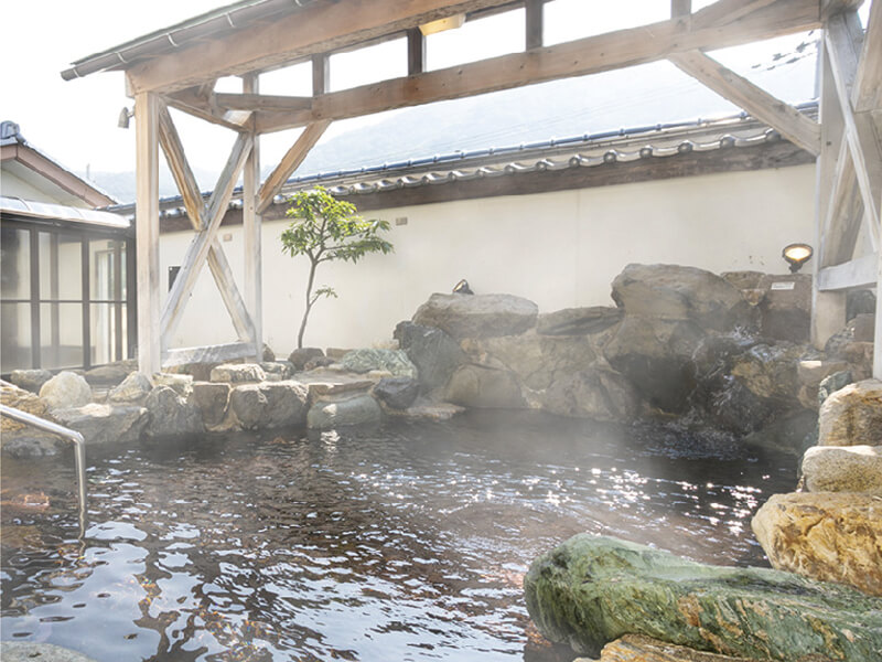
箱庭露天風呂をはじめ、檜露天風呂や岩露天風呂、遠赤外線サウナ・塩サウナなどリラクゼーションや館内の鍼灸院で心身共にリフレッシュできます。ナトリウム一塩化物温泉は神経痛、関節痛、筋肉痛、五十肩、運筋麻痺、うちみ、ねんざ、慢性消化器病、きりきず、やけど、慢性皮膚病、虚弱体質、慢性婦人病等に効能があります。
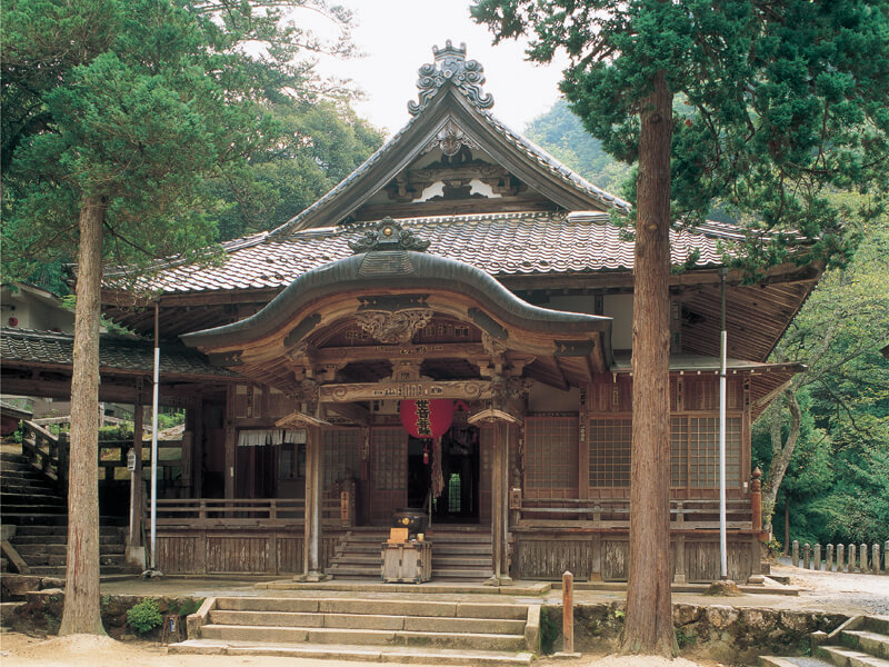
北陸三十三霊場の第七番札所。本堂には弘法大使の一夜の作と伝わる、聖観世音菩薩が安置されています。夜明けを告げる鵜の声で彫るのを止めたために右手首より先がなく、片手観音とも呼ばれ、手足の病気や怪我にご利益があるとされています。
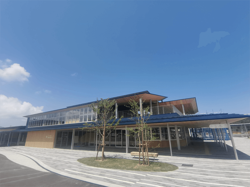
再生可能エネルギーを活用して運航する電池推進遊覧船を楽しめます。電池推進遊覧船にはガイドが乗船し、クルージングをより楽しいものにしてくれます。令和5年4月に、三方五湖のひとつ久々子湖の湖畔に完成しました。カフェを併設しているため観光やサイクリングの休憩にも気軽に立ち寄れるスポットです。
JR小浜線美浜駅からすぐの道の駅。美浜町産品や福井名物を中心とした直売所、美浜産の米粉を使ったパスタとパンケーキのカフェ、美浜穴子や活イカ(※ディナーのみ)をご用意した定食居酒屋、夜営業のバーなど美浜の食を楽しめる店舗のほか、託児所、キッズスペース(無料)、イベントスペース、スタジオなど、様々な機能を備えた道の駅です。
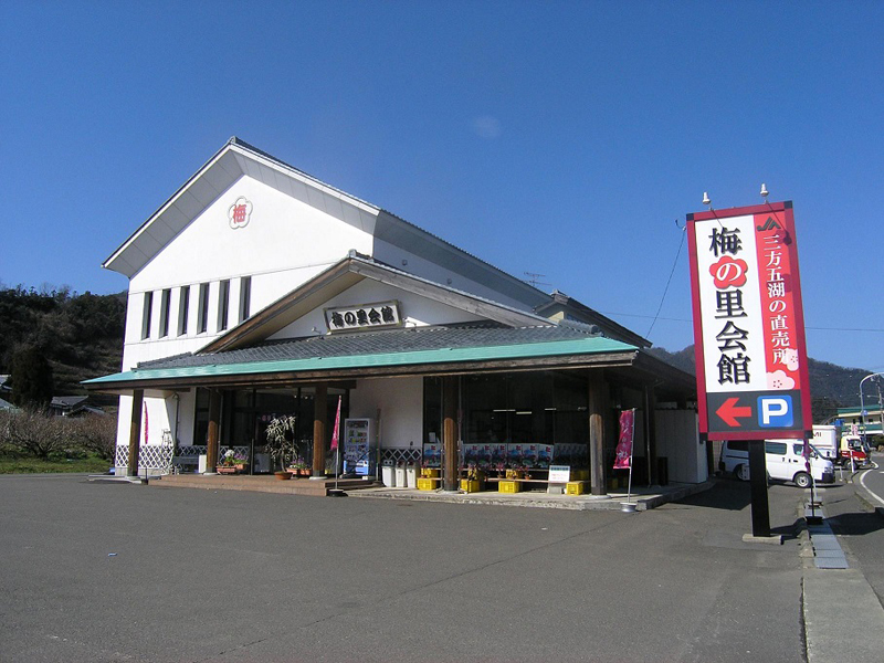
若狭町特産「福井県」の梅干し製造直売所。福井県は約200年前の江戸時代より栽培が続いており、種が小さく果肉が厚いのが特徴です。梅の里会館では、併設工場にて梅の天日干しから味付け・製品出荷に至るまですべてを手作業で行い、県内直売所や全国各地に発送・販売をしております。人気の梅干しや梅ソフト・梅茶の試飲販売の他、6月は店頭で青梅の販売を行っております。
