コース・マップ検索
宇和海しおさいオレンジ輪道
距離 Distance:
81.4km
獲得標高 上り Elevation Gain (Up):
980m
獲得標高 下り Elevation Gain (Down):
977m
最大標高差 Maximum elevation difference:
298m
八幡浜市から西予市へと続く前半部は、宇和海の美しい景観を堪能できる海岸線、小刻みにアップダウンを繰り返しながら上って行く後半からなるコースで、高い位置から宇和海を眺められる法華峠は絶景ポイントのひとつ。重要伝統的建造物保存地区である卯之町を通るなど、海・山・里の景色を一度に楽しめる。
The first half, which continues from Yawatahama City to Seiyo City, is a course consisting of a coastline where you can enjoy the beautiful scenery of the Uwa Sea, and the second half where you go up and down in small increments, and Hokke Pass, where you can see the Uwa Sea from a high position, is one of the scenic points. You can enjoy the scenery of the sea, mountains, and villages all at once, such as passing through Unomachi, which is an important preservation district for traditional buildings.
コース掲載マップ 愛媛マルゴト自転車道「宇和海しおさいオレンジ輪道」
しまなみ海道を中心に全県域を誰もが自転車に親しみ、誰もが自転車を楽しめる「愛媛マルゴト自転車道」を展開することで、“愛媛がサイクリングパラダイス”となることを目指している。
マップ詳細へ
オススメスポット ビュースポット いきもの・植物 グルメ ショッピング 道の駅 温泉 宿泊 病院 レンタサイクル 自転車販売店 サイクリングサポート トイレ その他
※オンラインの地図上でサイクリングルートが閲覧できるウェブサイト「ルートラボ」が2020年3月末でサービス終了したため、「bikemap」に変更したことで、bikemap内の距離や高低差に誤差が生じている場合がありますが、ご理解ご了承の程、よろしくお願いします。
コース周辺スポット
全て
オススメスポット
ビュースポット
グルメ
ショッピング
道の駅
病院
レンタサイクル
自転車販売店
サイクリングサポート
トイレ
で絞り込む
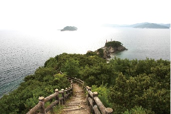
自然休養林諏訪崎
宇和海に向かって延びる全長約3kmの岬。四季折々の花が咲く約2kmの遊歩道を抜けた先端からは宇和海を望む美しい景色が広がる。
住所:八幡浜市栗野浦
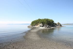
ねずみ島
大釜地区の100mほど沖合いにある、ねずみが海上に座っているような形をした小さな島。干潮時は歩いて渡ることもできる。
住所:八幡浜市大釜
四国西予ジオパーク(須崎海岸)
天気が良ければ九州まで見渡せる岬。船の航海安全と漁業の繁栄を祈る須崎観音が建てられていて、一回のみ鳴らすことができる鐘楼もある。
住所:愛媛県西予市三瓶町周木
あけはまシーサイドサンパーク
約300mのきめ細やかな白い砂浜「カッパビーチ」をはじめ、オートキャンプ場などを備えたレジャー施設。シーカヤックやスキューバーダイビング体験もできる。
住所:愛媛県西予市明浜町高山甲461-1
TEL:0894-64-1330
営業時間:
8:30~17:15
定休日:
年中無休
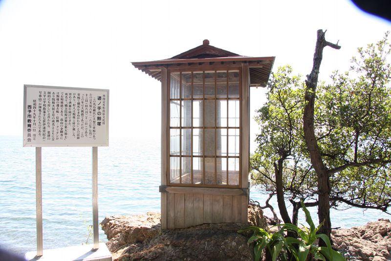
碆ノ手の鯨塚
江戸時代の大飢謹の時に人々を餓死から救った大鯨に謝意を表し供養した鯨塚。近くには大鯨が流されないように縄で括り付けたと伝わる子持岩も。
住所:西予市明浜町高山乙283
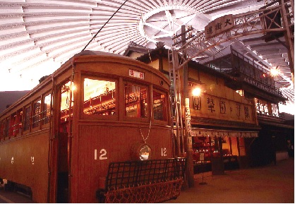
愛媛県歴史文化博物館
実物資料のほか、古代から現代まで各時代を象徴する建物を実物大に復元することにより、愛媛の歴史や民俗を詳しく紹介。昔の遊び道具に触れられるコーナーも。
住所:西予市宇和町卯之町4-11-2
TEL:0894-62-6222
営業時間:
9:00~17:30(入館17:00まで)
定休日:
月曜日(第1月曜日、祝日及び振替休日にあたる場合は翌日) ※小・中・高校生の春休みと夏休み期間中は無休、年末年始(12/28~1/1)
料金:大人510円、中学生以下無料、高齢者(65歳以上)260円
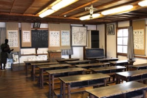
開明学校
日本的木造建築の中に洋風のアプローチをとりいれた小学校。現在は教育資料館と利用され、昭和前期までの教科書を収蔵・展示。
住所:西予市宇和町卯之町3-109
TEL:0894-62-4292
営業時間:
9:00~17:00(入館16:30まで)
定休日:
月曜日(祝日の場合は翌日)、年末年始(12/29~1/3)
料金:[明治の授業体験(4人以上)]1人200円[入館料]大人500円、小人(中学生以下)300円、就学前は無料、障害者手帳(身体・精神)・療育手帳の保持者は無料
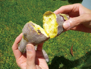
西予市役所 明浜支所 明浜産業建設課
かつて石灰産業で栄えた明浜地域の石灰を使って焼く焼き芋。水分が飛ぶことで通常のものより甘さが凝縮され絶品だと評判。
住所:愛媛県西予市明浜町高山甲3657
TEL:0894-64-1111
営業時間:
8:30~17:15[要予約]
定休日:
土曜日、日曜日、祝日
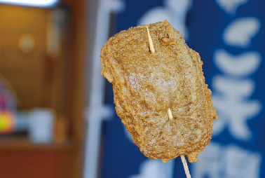
じゃこ天開洋
字和海で獲れた小魚を丸ごとすり身にして揚げた宇和海名物。各店ごとにいろいろな味がそろうので、食べ比べを楽しむのもいい。
住所:愛媛県西予市三瓶町朝立1-360-36
TEL:0894-33-2023
営業時間:
9:00~18:00(4月~9月は18:30まで)
定休日:
不定休
料金:じゃこ天(1枚)108円
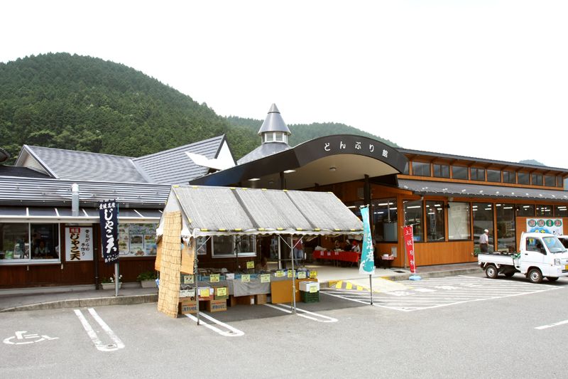
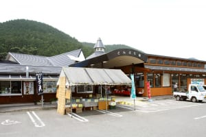
道の駅 どんぶり館
西予市の選りすぐりの特産品、加工品を一同に集め販売しており、ここでしか買うことができない地元産商品が目白押しで、ついつい時間の経過を忘れてしまうほど。地元の人が作った商品は、午前中に売り切れてしまう商品も多いので早めに訪れたい。また、行列ができるほどのじゃこ天や、手作りで仕込んだ自家製ジェラートも大人気。平成26年4月に、道の駅に登録された。
住所:西予市宇和町稲生118
TEL:0894-62-5778
営業時間:
8:00~18:00
定休日:
年始(1/1~1/2)
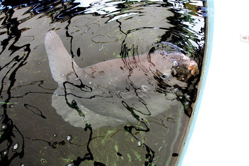
みかめ海の駅 潮彩館
三瓶港の近くに位置。新鮮な魚や野菜、絞りたてのみかんジュースを購入できる。またマンボウが飼育されるほか、海辺の生き物に触れられるタッチングプールもあり。
住所:西予市三瓶町朝立1番耕地438-287
TEL:0894-33-3001
営業時間:
[10月~3月]9:00~18:00[4月~9月]9:00~18:30
定休日:
水曜日(祝日の場合はその翌日)、年始(1/1~1/3)
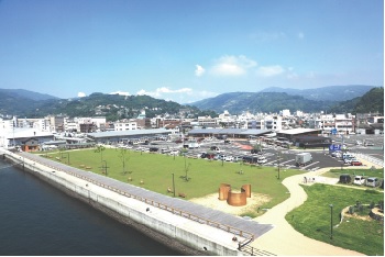
道の駅 みなとオアシス 八幡浜みなっと
港町・八幡浜らしい海のすぐそばにある道の駅。市内中心部にあり、商店街へのアクセスも良いため、市内観光の情報収集に最適な施設。旬な果物や野菜、魚介、肉類が豊富に終結する直産市「アゴラマルシェ」、四季折々の魚類400~500種類が集まる「どーや市場」や整備された緑地公園には、港に沿ってボードウォークが整備されており、港の向こう側にはみかんの棚田が広がっているため、潮風とみかんの香りを全身で受けながら散策を楽しむことができる。
住所:愛媛県八幡浜市沖新田1581-23
TEL:0894-34-6565
営業時間:
8:30~18:00
定休日:
年末年始
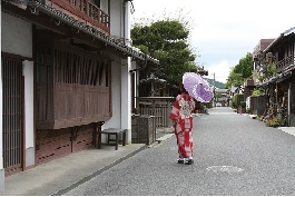
卯之町の町並み
宇和島藩の在郷町・宿場町として栄えていた当時の佇まいを残すエリア。旧街道沿いに江戸時代から昭和初期の家屋が数百mにわたり続く。
住所:愛媛県西予市宇和町卯之町
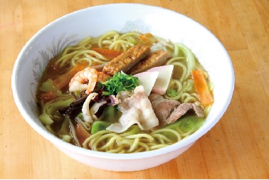
レストラン マリン
八幡浜市内には提供する店が50以上ある八幡浜のソウルフード。鶏ガラ醤油ベースのあっさりスープに八幡浜の魚介がたっぷり。
住所:愛媛県八幡浜市沖新田1586 観光ビル3F
TEL:0894-23-2600
営業時間:
8:20~19:30(LO 19:00)
定休日:
元旦
料金:八幡浜ちゃんぽん 600円
道の駅 みなとオアシス 八幡浜みなっと
住所:八幡浜市沖新田1581-23
TEL:0894-21-3710
営業時間:
9:00~21:30(受付18:00迄)
定休日:
年末年始(12月29日~1月3日)
料金:[クロス]4時間まで400円、当日返却700円、24時間まで800円
市立八幡浜総合病院
住所:愛媛県八幡浜市大平1-638
TEL:0894-22-3211
受付時間:
8:30~11:00
休診日:
土曜日、日曜日
西予市立西予市民病院
住所:愛媛県西予市宇和町永長147-1
TEL:0894-62-1121
受付時間:
8:00~11:00、13:00~16:00
休診日:
土・日・祝・年末年始
ワケスポーツ宇和店
住所:愛媛県西予市宇和町卯之町4-668-7
TEL:0894-62-0260
営業時間:
10:00~17:00
定休日:
水曜日
料金:1日2,000円
メセナドライブ
住所:愛媛県八幡浜市駅前1
TEL:0894-22-0266
営業時間:
10:00~17:00
定休日:
元旦
料金:[クロス]4時間まで400円、当日返却700円、24時間まで800円
DCMダイキ 宇和店
住所:愛媛県西予市宇和町卯之町4-518-3
TEL:0894-62-7671
営業時間:
9:00~19:30
定休日:
1/1