


![]()
![]()
![]()
![]()
![]()
![]()
![]()
![]()

東国三社の一つである息栖神社や、桜の名所を巡る。『究極のメロンパン』や神栖市の特産品であるスイートカクテルペッパーを購入できる。
Visit Ikisu-jinja Shrine, one of the three shrines in the East, and places famous for cherry blossoms. You can buy the “ultimate melonpan” and sweet cocktail peppers, which are a specialty of Kamisu City.
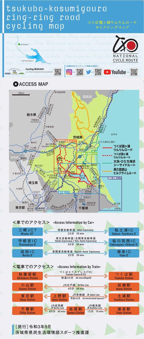
総延長は、ロングライド可能な180km!平坦なコース沿いには霞ヶ浦、日本百名山の筑波山など風光明媚なみどころが多く、筑波エリアでは、ヒルクライムも可能。
全てのサイクリストが、
それぞれのスタイルで楽しめるサイクリングロード
※オンラインの地図上でサイクリングルートが閲覧できるウェブサイト「ルートラボ」が2020年3月末でサービス終了したため、「bikemap」に変更したことで、bikemap内の距離や高低差に誤差が生じている場合がありますが、ご理解ご了承の程、よろしくお願いします。
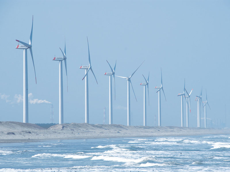
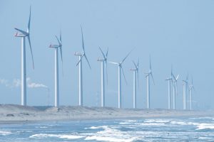
迫力ある風力発電施設の風車が立ち並ぶ。普段は砂浜が広がる波崎海岸だが、5月後半になるとハマヒルガオの花でピンク色に染まり、いつもと違った表情を見ることができる。
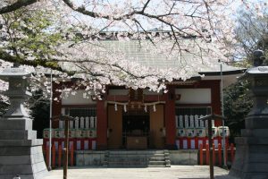
息栖神社は東国三社の一つであり、二千年以上の歴史を持つ由緒ある神社。東国三社参りが盛ん。境内には三笠宮崇仁親王の参拝記念に植えられた宮桜がある。東国三社を訪れることで完成する東国三社お守りが大好評。御朱印をいただく際には、三笠宮崇仁親王殿下から下賜された印も押される。
(無料駐車場・トイレ有)
広大な芝生公園や噴水、丘などがあり、一休みするのに最適。かみす防災アリーナは、災害時の避難場所になるほか、普段は温水プールやジムなどの施設を利用することができる。(無料駐車場約1200台)
洋上に巨大な風車が立ち並び、雄大な景色が望める。
サーフィンや海水浴ができる。近くに日川浜オートキャンプ場がある。
(無料駐車場約601台・トイレ有)
日帰りで楽しめる天然温泉施設。リラクゼーション設備も充実。
荘厳な雰囲気と春に咲き誇る桜は見事な景色。
神栖市のおいしいものを皆に知ってもらいたいとの思いで消費者に健康と笑顔を運ぶような特産物を販売している。「百姓が立ち上げた、農業のすばらしさを伝えたい!」を合言葉に誕生した直売所。農業にイノベーションの新しい風を起こそうという思いが込められている。
霞ヶ浦の下流にある常陸利根川の堤防上にある全長約15kmのサイクリングロード(自転車歩行者専用道)で、みどりの風吹く田園風景を楽しみながらサイクリングをすることができる。沿線には無料駐車場やトイレが設置された休憩所もあり。
国内外のスーパーカーを展示。雑誌やグッズ等のコレクションも楽しめる。国内外のスーパーカーを展示。雑誌やグッズ等のコレクションも楽しめる。(土日祝日のみ開館)
常陸利根川と北浦がぶつかるところに広大な外浪逆浦がある。その名のとおり、夕日の絶景ポイント。(無料駐車場・トイレ有)
お洒落な店内で気軽にイタリアンを楽しめる。本格的なかまどで焼くピッツァをいただくことができる。オーナーも自転車の愛好家。
神栖市内有数のホテル。東京駅までの高速バスの発着拠点になっており、市の中心的施設。ホテルの売店アイリスでは、話題のサバ缶を買うことができる。また敷地内には天然温泉がある。
