


![]()
![]()
![]()
![]()
![]()
![]()
![]()
![]()
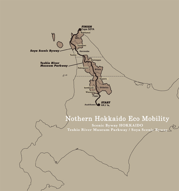
北海道の真ん中(あたり)の旭川空港から日本のてっぺん「宗谷岬」まで、自分の自転車で3日間走り続けるちょっと尖ったコースはいかがでしょう。北海道の魅力はなんといっても“道”。何キロも信号のない道が続いたり、どこが終わりかわからないほどの真っ直ぐに続く道。見える景色も、自然の香りも、進むたびに変化し、走る“道”の全てが美しく、自転車で走るには、たまらない爽快感があります。
From Asahikawa Airport in the center of Hokkaido to “Soya Cape” at the top of Japan, how about a slightly sharp course where you can continue running for 3 days on your own bicycle. The appeal of Hokkaido is, after all, the “road.” The road continues for many kilometers without traffic lights, and the road continues so straight that you don't know where it ends. Both the scenery you can see and the scent of nature change as you go, and every “road” you run on is beautiful, and riding a bicycle has an irresistible sense of exhilaration.
原始的でダイナミックな自然と手付かずの美しい風景が残る日本最北端エリア。豊かな自然環境を活かした本物の遊び(アクティビティ)と旬の地域食材,北の歴史・文化に触れながら,自分の力で進み,その地の良さを知る,新しい旅のカタチがここにあります。
マップ詳細へ※オンラインの地図上でサイクリングルートが閲覧できるウェブサイト「ルートラボ」が2020年3月末でサービス終了したため、「bikemap」に変更したことで、bikemap内の距離や高低差に誤差が生じている場合がありますが、ご理解ご了承の程、よろしくお願いします。
