


![]()
![]()
![]()
![]()
![]()
![]()
![]()
![]()
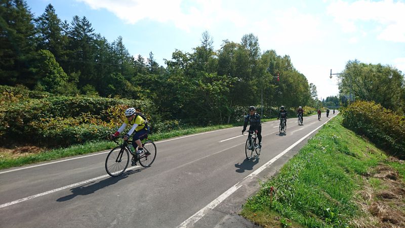
中川町のお勧めビューポイントを巡るサイクリングコース。ナポートパークを出発し、道道541号線を、右側にJRとパンケ山・ペンケ山を望み、左側に天塩川と一緒に北上します。町内最果ての無人駅「JR歌内駅」から歌内橋を渡って直ぐ右に曲がり、国道40号に出たところで、南側へ向かうと、きれいな月の形をした「三日月沼」があります。運が良ければ、晴れた日はこの辺りから秀峰「利尻山」も見えるかも!?そこから国道40号を少し南へ向かい、歌内橋に向かって手前の堤防に入ります。車も気にならない堤防沿いを快走!!「道の駅なかがわ」で人気の、中川町自慢の“ハスカップ”ソースのソフトクリームで休憩してナポート・パークへ。
A cycling course that goes around recommended viewpoints in Nakagawa. Depart from Naport Park, take Route 541, look at JR and Mount Panke and Mount Penke on the right, and head north along with the Teshio River on the left. From the unmanned station “JR Utanai Station” at the end of the town, cross Utanai Bridge and immediately turn right, and when you go out on National Route 40, head south, and you will find “Mikazuki Swamp” in the shape of a beautiful moon. If you're lucky, you might be able to see the peak “Mount Rishiri” from around here on a clear day!? From there, head slightly south on National Route 40 and enter the embankment in the foreground towards Utanai Bridge. Drive fast along the embankment where cars don't even bother! After taking a break at “Roadside Station Nakagawa,” a soft serve ice cream with Nakagawa's specialty “lotus cup” sauce, Nakagawa Town is proud of, then head to Naport Park.
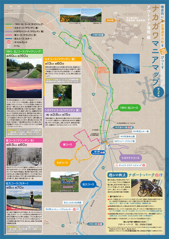
※オンラインの地図上でサイクリングルートが閲覧できるウェブサイト「ルートラボ」が2020年3月末でサービス終了したため、「bikemap」に変更したことで、bikemap内の距離や高低差に誤差が生じている場合がありますが、ご理解ご了承の程、よろしくお願いします。
静かな森と川を背に佇むナポート・パークは、アウトドア体験が手軽に楽しめる“中川町で遊ぶコンテンツ”が揃っています。自転車、カヌー、釣り、キャンプ、焼肉・・・自分の工夫次第で遊び方無限!
冬の遊びスポット!昔ながらのロープリフト。コースはちょっと短いけど、急斜面、緩斜面有り。
ドライブインといえばやっぱり「ラーメン&カレーライス」のセットが定番!?しかしここのセットは、どちらも通常サイズででてきちゃいます!
開店を待ちどおしく、美味しくて無言になってしまうほどの中華料理やさん。必ずやまた食べたくなる味。〆のラーメンが絶品。
ゆっくりのんびり温泉の後に。宿泊客以外でも利用でき、コーヒー一杯でも是非どうぞ。定番の「あんかけやきそば」が人気。
毎月月末に開店する、雰囲気も味もいい粋なカフェ。中川町の陶芸や木工作品、雑貨なども販売。ここでしか買えないものも!?詳しくはホームページを!
お腹空いたら、飲みたくなったら名の通り、「きまま」にふらっとたちよってみよう。遅くまで開いているのもまた嬉しい♪「ふんわりお好み焼き」(要予約)は絶品!
宴会!といえばここ。どのメニューも美味しいけれど、お店自慢の秘伝のタレの豚丼は、お腹がいっぱいでも〆に食べたくなってしまう。タレはお土産にしても♪
気さくなママ、雰囲気抜群のお店。宴会料理(要予約)もボリューム満点、一次会も二次会も両方楽しめちゃう!
おしゃれな雰囲気の小さなお店。もう少し飲みたいな、ちょっと歌いたいなと思ったら是非どうぞ!
H27年にリニューアルオープン。中川町の特産品ハスカップを使ったサワーが飲めるのはここだけ!
キャンプ場に隣接している公共温泉施設。キャンプ場に泊まっている人も、朝早くから温泉に入れるので嬉しい。室内用の自転車スタンドの貸し出しや空気入れも用意しています。
–
商店
–
駄菓子・バイク修理
–
自転車・金物・工具
