![]()
![]()
![]()
![]()
![]()
![]()
![]()
![]()
絶景の琵琶湖大橋を渡り、そのむかし若狭から京へたくさんの海産物届けられたことでその名がつけられた鯖街道を北上、安曇川付近で湖岸へ出た後、湖岸を南下して戻る。前半の途中越えはきついが、登りははそこまででほぼ終了。その後は心地よい下りが続く、滋賀の山と湖を堪能できるルート。
Cross the spectacular Lake Biwa Bridge, go north on the Saba-kaido Road, which is named because many marine products were delivered from Wakasa to Kyoto once upon a time, exit to the lakeshore near the Azumi River, and then head south along the lakeshore. Halfway through the first half was tough, but the climb was almost over. Afterwards, a pleasant descent continues, a route where you can enjoy the mountains and lakes of Shiga.
※オンラインの地図上でサイクリングルートが閲覧できるウェブサイト「ルートラボ」が2020年3月末でサービス終了したため、「bikemap」に変更したことで、bikemap内の距離や高低差に誤差が生じている場合がありますが、ご理解ご了承の程、よろしくお願いします。

無料駐車場が朝7時30分から利用できるなど、サイクリストの発着地としてオススメです。サイクリングの後は、琵琶湖を眺めながらおいしいスイーツやグルメが楽しめるほか、その他施設も充実し、1日中楽しめる施設ですので是非ご利用ください。
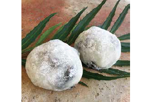
幻と称される滋賀羽二重と香り高い小豆の大福餅は、ビワイチスイーツの定番。サイクリストにとってエネルギーチャージ&一日の癒しには最高の一品です。
高島びれっじ内にある、築100年の納屋を改装した趣ある空間で、地元生産者からの「命を頂いた実感のある食材」を使用。その素材を活かした自家製パスタなどのイタリアンをいただけます。
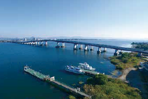
守山市と大津市を結ぶ琵琶湖に架かる橋。長い橋は1,400mあり湖面からの高さは26.3m。晴れていれば琵琶湖が一望でき、最頂部の展望デッキは、サイクリストに人気の撮影スポットとなっています。
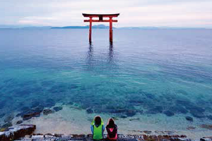
湖中に朱塗りの大鳥居があり、国道161号線をはさんで社殿を構える神社。「白鬚さん」「明神さん」の名で広く親しまれ、また、「近江の厳島(いつくしま)」とも呼ばれています。